Maps beside the Book of Jubilees — The Division of the Earth
Why these two maps stand beside Jubilees
In its eighth to tenth chapters the Book of Jubilees records the division of the earth among the sons of Noah — the portions of Shem, of Ham and of Japheth, assigned by lot under oath, with the warning against seizing a brother’s portion that the Collection’s teaching draws on (Jubilees 9–10). Genesis 10, the Table of Nations, is the same division in the canon’s own table. The two maps below are how later centuries drew that world: first, the lands themselves as a great 19th-century atlas reconstructed them; second, the division itself, drawn as geography by the 18th century’s great biblical scholar. Neither map is ancient. Neither governs a line of the text. They are set here so the reader can see the stage — and can see, in the captions, exactly how far each map’s knowledge reaches and where it stops.
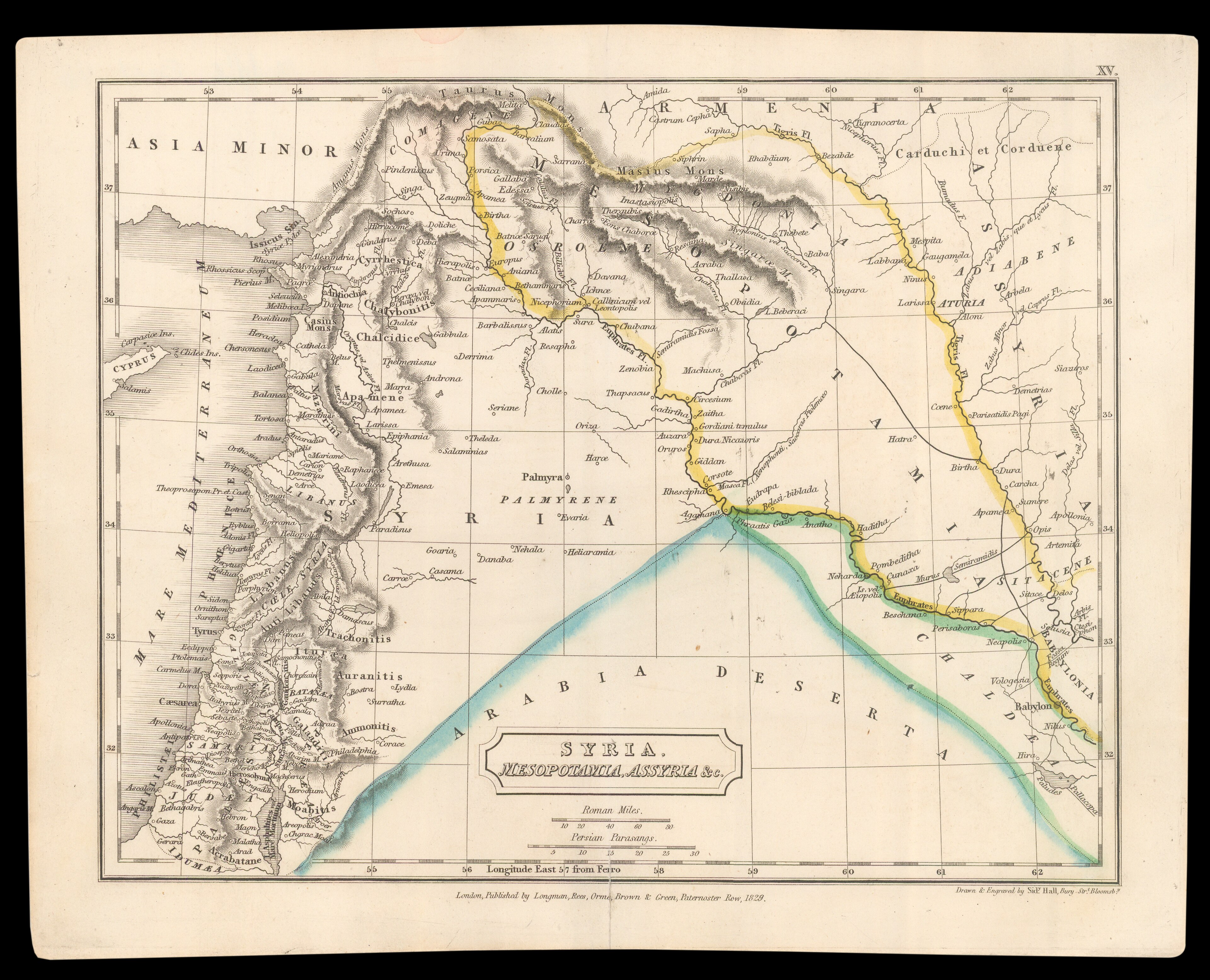
1 · Syria, Mesopotamia, Assyria &c. — the lands of Genesis.
Maker: Sidney Hall, engraver, London · Date: plate of Hall’s atlas work, c. 1830 · Title: Syria, Mesopotamia, Assyria and c. · Source: National Library of Israel, Eran Laor Cartographic Collection, via Wikimedia Commons — public domain, verified on the file page, 2026-10-28.
What it shows: the stage of the patriarchal narratives as a 19th-century atlas drew it — the two rivers of Mesopotamia, Assyria and Babylonia, Syria and the approaches to Canaan: the country of Ur, of Haran, of Babel, within which Genesis 11–50 and the opening of Jubilees move.
What it does not show: any ancient man’s map. It is a reconstruction made some three thousand years after the events, and its identifications of sites are its own century’s scholarship; where the text is silent — the site of Eden, the detail of Abram’s road — the map’s settled look is the atlas’s confidence, not the text’s.
A period document: borders and names are its maker’s, not today’s. An aid to reading; the text governs.
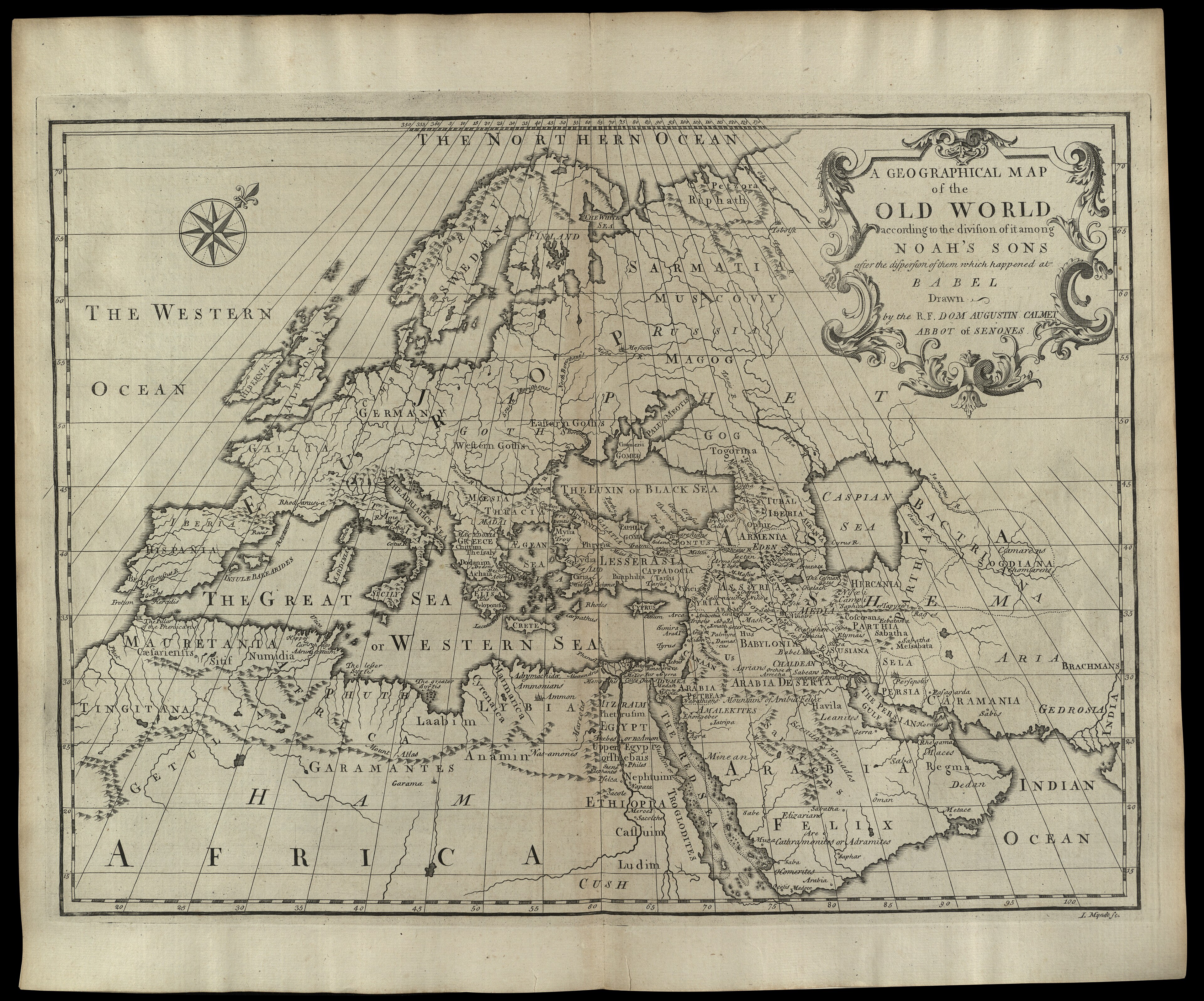
2 · The Old World divided among Noah’s sons.
Maker: Dom Augustin Calmet; engraved by I. Mynde · Date: for the English edition of Calmet’s Dictionary of the Bible, 1732 · Title: A Geographical Map of the Old World according to the division of it among Noah’s Sons after the dispersion of them which happened at Babel · Source: National Library of Israel, Eran Laor Cartographic Collection, via Wikimedia Commons — public domain, verified on the file page, 2026-10-28.
What it shows: the Table of Nations drawn as geography — JAPHETH lettered across Europe, SHEM across Asia, HAM across Africa, Eden set in the Armenian highlands and the names of Genesis 10 placed in their countries: the same threefold division that Jubilees 8–10 records by lot and by oath.
What it does not show: the allotment’s own boundaries as Jubilees speaks them — the rivers, seas and portions named in the text’s words; Calmet drew one scholar’s reconstruction of the division, not the division’s record. The Americas, the far east beyond India and the southern lands lie outside his frame entirely.
A period document: borders and names are its maker’s, not today’s. An aid to reading; the text governs.
The pattern this pilot sets
Per-book map companions will follow this page’s form: a small set of period maps beside the book, each captioned in full, each labelled an aid. This page is not deployed and is not linked from the Book of Jubilees reading page in this pass; the linking of companions into the reading pages is a later step of the programme, on the register’s extension plan.
Record: Maps Programme register — MAPS_PROGRAMME_REGISTER_2026-10-28.md. The allotment text itself stands in the Collection’s held master of Jubilees (Editorial Master v03, 50 chapters), chapters 8–10.